Umujyanama: A Free Farm Advisory Tool for Every Farmer in Rwanda
Find your land, say what grows on it, and Umujyanama reads your field from satellite every night, then explains it in Kinyarwanda. It is free for every farmer in Rwanda.
Umujyanama ("the adviser" in Kinyarwanda) is a free farm advisory service from Hekitari for the farmers of Rwanda. A farmer finds their land among every registered parcel in the country, or draws it on the map, says what crop is growing and when it was planted, and from then on the field is read from satellite every night: how the crop is doing for its growth stage, what it should yield, and what the soil, the slope and the weather mean for it. It is live at umujyanama.hekitari.com, and there is nothing to pay.
Why did Hekitari make a farm advisory tool free?
Most of the intelligence Hekitari builds was first sold to lenders, cooperatives and agribusinesses. Umujyanama turns the same engine around and puts the farmer at the centre. It is Hekitari's Crop Health Monitoring rebuilt for the public: the same satellite pipeline, crop-aware assessment and map, with the variety yield figures from Smart Farm Manager and the land-suitability study from InvestWise. An extension officer cannot visit every field every week. A satellite can, and an adviser on the phone can explain what it saw in the farmer's own language.
What does Umujyanama tell a farmer about their field?
Each field opens on a page with six tabs, all in Kinyarwanda by default and in English with one tap on EN:
- Incamake (overview): a clear verdict (Kimeze neza cyane, Kimeze neza or Gifite ikibazo), the growth stage against the crop's calendar, and why, read aloud on request
- Uko wahindutse (trends): twelve months of NDVI, NDRE and NDMI against the curve a healthy crop would follow, drawn on the field one 10 m pixel at a time
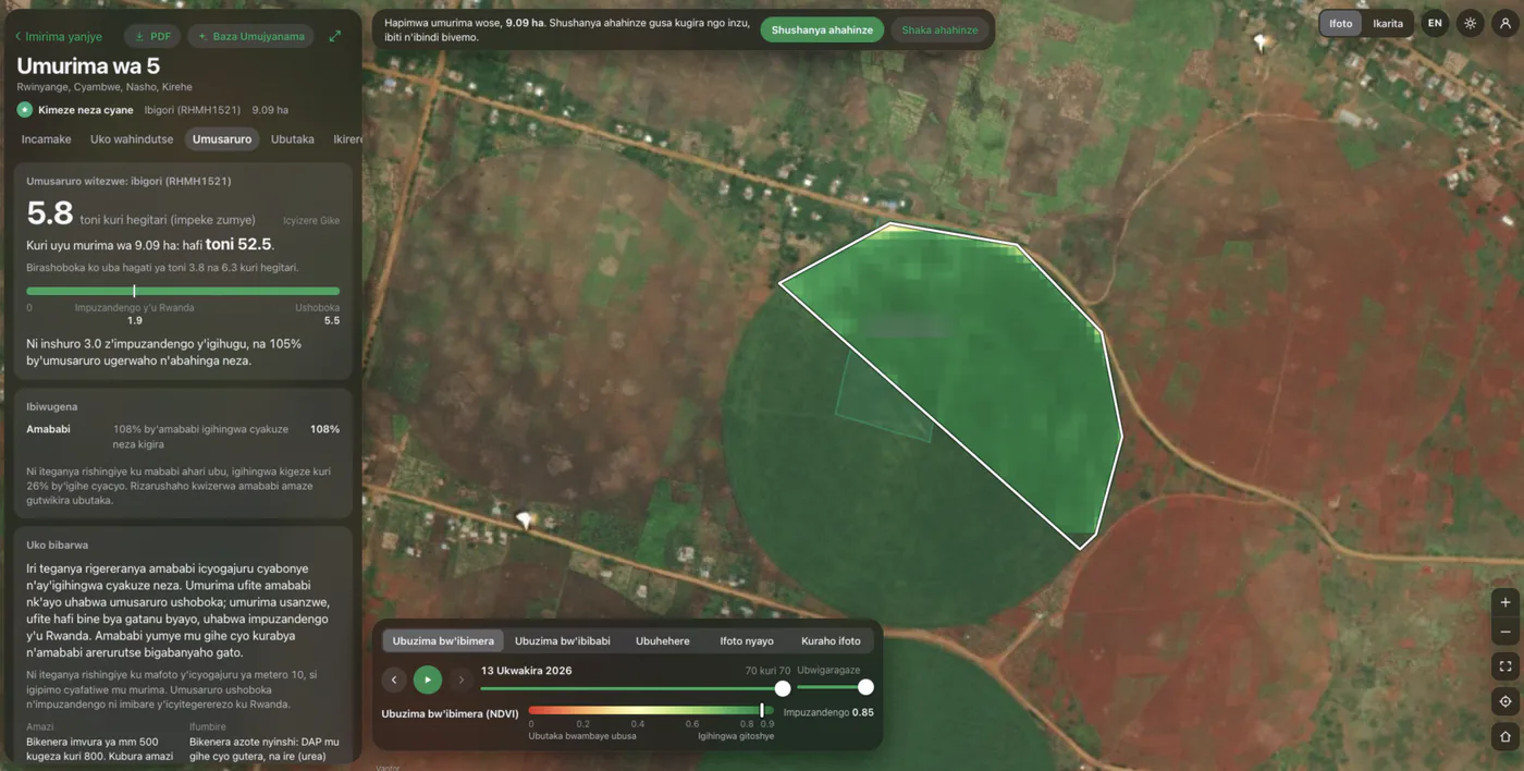
- Umusaruro (yield): an estimate in tonnes per hectare with a range, the total for the field's own size, and how it compares with Rwanda's average and the attainable yield of that variety
- Ubutaka (soil and terrain): texture, pH, carbon, N, P, K and CEC read for the crop grown, plus altitude, slope and whether the slope calls for terraces
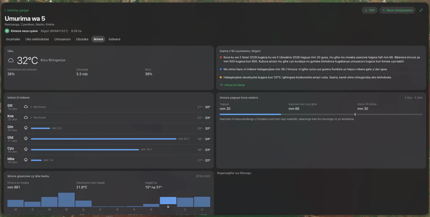
- Ikirere (weather): today and the next five days, advice for this crop this week, the water the crop needs against forecast rain, and rain since planting against the ten-year normal
- Indwara (disease): photograph a plant and the adviser diagnoses it, knowing the crop, its stage and the satellite reading, with treatments available in Rwanda
Can farmers ask questions in Kinyarwanda?
Yes. Baza Umujyanama ("ask the adviser") takes a question typed or spoken in Kinyarwanda and answers in Kinyarwanda, read aloud. Asked from inside a field, it has that field's whole record in front of it: the crop, the variety, the planting date, the satellite readings, the soil and the weather. It also answers in English, French or Kiswahili when spoken to in them.
Does Umujyanama only monitor fields that are already planted?
No. Before anyone puts money into a piece of land, Umujyanama can say what it is good for. Draw a polygon anywhere in Rwanda, or pick a field, and the ground is studied: soil, slope, altitude, climate, and InvestWise's village crop-suitability and fertiliser layers. Every crop is scored against it on FAO's classes, with what holds each one back, and the adviser turns the study into plain advice on which crops to grow, what the soil needs and what the risks are.
Does it work on a basic phone with a weak connection?
Umujyanama runs in the browser and installs to the home screen like an app, so there is no app store to go through. It is built for poor networks: fields already opened, their trends, soil and the last weather reading stay on the phone, and a farmer can draw a new field, photograph a sick plant or type a question with no connection at all. Each is kept and sent when the network returns.
How much does Umujyanama cost?
Nothing. Nobody is asked for an account at the door: a visitor can find their land and read the first analysis straight away. To keep the field and unlock soil, weather, disease and the adviser, they open a free account with a name, a phone number or email, and a district, and are signed in at once. Each account can follow up to 25 fields, and each one is brought up to date from satellite every night.